
Heavy rainfall has caused severe waterlogging across Mumbai, disrupting traffic and daily life. The India Meteorological Department issued a red alert for Mumbai and surrounding districts, advising precautions. Specific areas recorded over 200 mm of rainfall, and the IMD forecasts continued heavy rains for the Konkan region, Goa, South Gujarat, Odisha, and Central India.
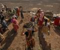
The Indian government has identified 111 districts as 'most vulnerable' to crop damage due to a 43 per cent monsoon deficit, driven by El Nino, which threatens kharif sowing. Agriculture Minister Shivraj Singh Chouhan stated that weak monsoon conditions are expected to persist until July 2, prompting contingency plans and recommendations for alternative, less water-intensive crops.

Kolkata Knight Riders face the threat of rain disrupting their IPL match against Punjab Kings, potentially impacting their chances of securing their first win of the season.

Several parts of Mumbai received heavy rainfall in the last 24 hours, with Vikhroli reporting the highest downpour. The IMD reported significant rainfall in various areas of the city.

The first cloud-seeding trial has been conducted in parts of Delhi, including Burari and Karol Bagh areas, aimed at inducing artificial rain to tackle air pollution.
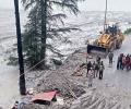
Experts question whether a cloudburst caused the recent flash flood in Uttarkashi, India, citing insufficient rainfall and other potential factors like ice chunks, rockfalls, or landslides.

Heavy rains across India have led to widespread flooding, causing damage to infrastructure, displacement of residents, and disruption of normal life. Rescue efforts are underway in affected areas.

Data since 2005 show that the five years with the highest rainfall saw average market returns of 8.98 per cent, while the five driest years returned 25.7 per cent on average.

The recent helicopter crash near Kedarnath, in which seven lives were lost, has proven yet again that aviation regulatory authorities have not learnt lessons from similar air mishaps in the challenging Kedar valley and have done little to improve flying conditions.

Western disturbances are near Pakistan-Afghanistan and are moving towards Delhi and thunderstorms or dust storms are likely to be experienced in northwest India, senior scientist at IMD RK Jenamani told ANI.

'Nobody asked us to work on this. It was on our own that we decided to embark on this journey.'

The IMD had said the Southwest Monsoon would hit parts of north India including Delhi on July 10, but it had not occurred till Sunday evening.

India will receive normal monsoon this season, country's meteorological department said on Wednesday in its forecast for the Southwest monsoon that covers 75 per cent of the country, and thereby may bring much-needed respite to the economy, which is reeling under the catastrophic effect of the Covid-19 pandemic.

The IMD has also issued a red-coded warning alert to the Odisha and West Bengal coasts.

A sudden downpour in Delhi caught citizens off guard and caused heavy waterlogging and traffic jams on Tuesday while Mumbai breathed a sigh of relief as showers stopped a day after heavy rain brought the metropolis to its knees.

The IMD has fancy weather-monitoring radars in the name of providing better forecasts.

After making landfall near Puducherry on November 30, Cyclone Fengal weakened on Sunday, but torrential downpour under its influence paralysed the union territory, with the Army stepping in to evacuate stranded persons in inundated streets.

As weather patterns grow more unpredictable due to climate crisis, India is taking a giant leap with "Mission Mausam" to improve weather understanding and forecasting through expanded observation networks, better modeling and advanced tools like AI and machine learning.

The global financial crisis has empowered fiscal conservatives in India.

Sowing had started on a sluggish note in several parts of the country because of delay in the onset of the monsoon but has picked up pace subsequently as the rains progressed and performed appreciably well in August.

The threshold for a heat wave is met when the maximum temperature of a weather station reaches at least 40 degrees Celsius in the plains, 37 degrees in coastal areas, and 30 degrees in hilly regions, and the departure from normal is at least 4.5 notches.

Authorities were on their toes in Banaskantha and Patan districts and relocated thousands of people residing in low-lying areas to safer places, they said.

Above-normal heatwave days are predicted in most parts of central, east and northwest India during this period.

Any long dry spell could cause moisture stress in the standing crop during the crucial maturing stage and also make it prone to pest and disease attacks.
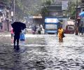
Some low-lying places like Hindmata, and areas in Dadar and Sion, including the Gandhi Market and road number 24 in Sion, were inundated, forcing pedestrians to wade through the water and making it difficult for motorists to commute.

Temperatures in March will be critical to determining the impact of any unusual heatwave conditions on this year's wheat crop in North India. It is that time of the year when the crop enters its vital grain-filling stage, say meteorologists and crop experts. So far, the high day temperatures in the North are not believed to have any significant impact on the final yields since the crop hasn't entered a stage where heat affects yields.

A tormenting heatwave swept through North India on Sunday with the mercury crossing 49 degrees Celsius in pockets of Delhi, while the weather office forecast some relief Monday onwards.

Yuvraj, 30, was part of the Indian team that played in the 2014 World Cup at The Hague in the Netherlands.

According to the IMD forecast, monsoon is likely to be normal this year.

"The season averaged maximum temperatures in Himachal Pradesh, West Rajasthan, Konkan, Goa, Coastal Karnataka, Kerala and Arunachal Pradesh are likely to be higher than normal by 0.5-1.0 degree Celsius," the Met department has said in its forecast.

This may rescue pulses, cotton and oilseed sowing; rain revival in the south to take longer

The 'eye' or centre of the cyclone is estimated to be 15 km in spread so it will take nearly an hour to cross the coast completely, officials said adding that the impact of the storm will be maximum for the next six hours

Heavy rains lashing Mumbai since Sunday have thrown rail, air and road traffic out of gear, with several trains and flights being cancelled. With IMD forecast of heavy rains for Tuesday, the authorities declared a holiday in the city and adjoining regions, asking people to avoid stepping out of their houses.

Till June 30, the southwest monsoon was 33 per cent lower than normal, which is among the worst in the last five years, with 28 of the 36 meteorological divisions recording deficient rain.

The IMD has said temperatures in most parts of the country from March to May would be 'above normal'.

Subdued exports remain an area of concern.

With the cyclone set to make landfall on Wednesday, Maharashtra and Gujarat activated their disaster response mechanism, deploying NDRF teams and evacuating people from areas likely to be hit.

In many parts of central and north India, monsoon reaches only in July.

Cyclone Nisarga slammed Maharashtra coast with wind speeds of up to 120 kmph, making landfall at 12.30 pm at Alibaug near Mumbai. The process was completed by 2.30 pm, a senior India Meteorological Department official said. Alibaug witnessed wind speeds of up to 120 kilometres per hour. It weakened into a 'deep depression' late on Wednesday evening, the IMD said.
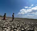
'The first two months of monsoon are not looking good.' 'In case both the halves fail, it is going to be misery.'
